
NEWS
San Andreas and San Jacinto Faults Hit 1,000-Year Stress High
A University of Hawaii study finds the San Andreas and San Jacinto faults at 1,000-year stress highs, with Cajon Pass able to enable joint rupture.

The San Andreas and San Jacinto fault systems in Southern California now sit at their highest tectonic stress in 1,000 years. A new study published June 10, 2026 in the Journal of Geophysical Research: Solid Earth says a single earthquake could rupture both faults at once. The model also introduces a separate mechanism the authors call an earthquake gate at Cajon Pass.
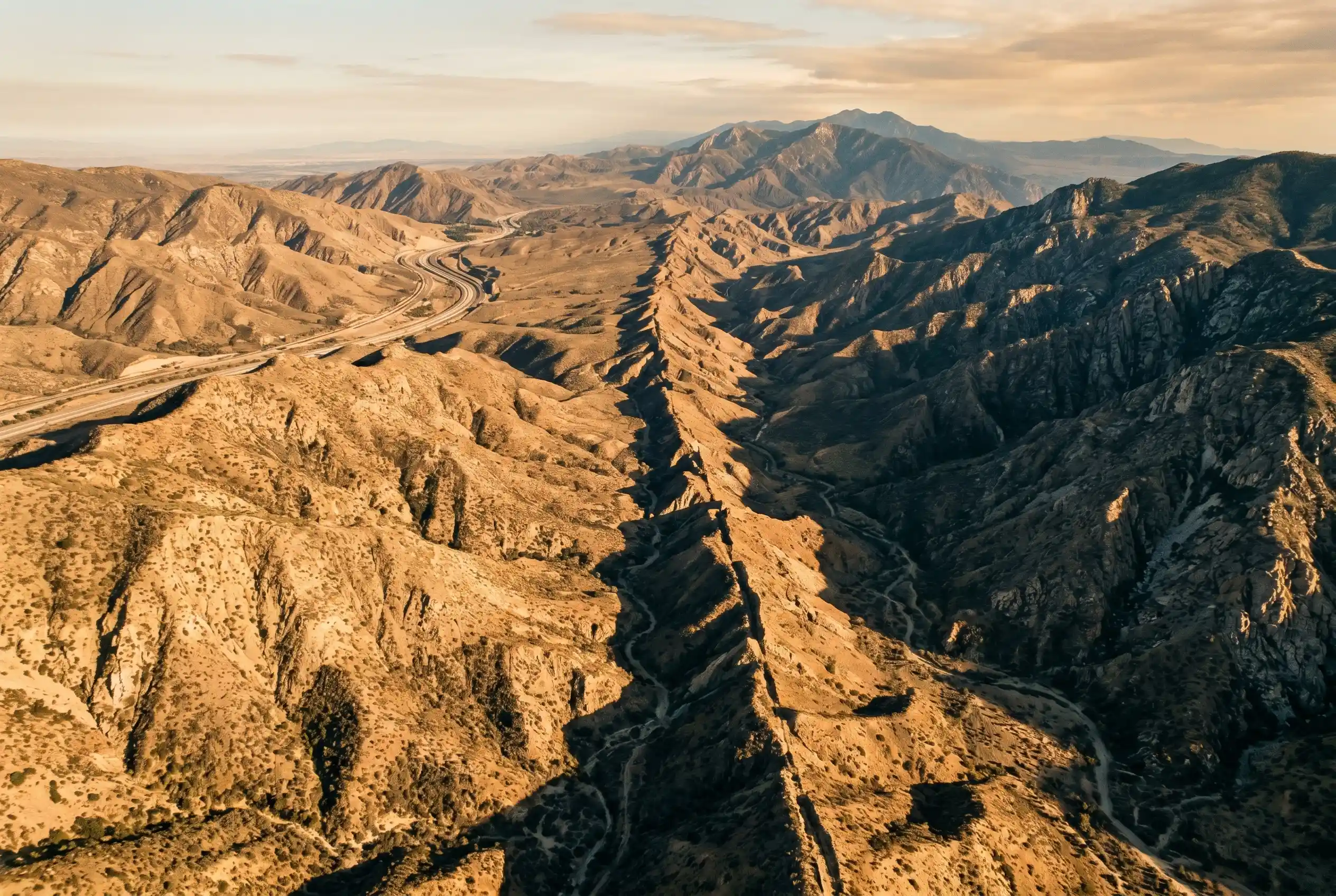
Cajon Pass is a mountain crossing about 63 miles northeast of Los Angeles where the two fault systems come within a few miles of each other. Under current stress conditions, the model suggests the gate could allow a rupture on one fault to propagate into the other, producing a single earthquake far larger than either fault could generate alone.
What the Stress Reading Shows
The study compared modeled stress on the two fault systems against a 1,000-year record reconstructed from geological evidence. It concluded that present-day stress on multiple segments now matches or exceeds the highest values in that record. “Right now, with stress at historically high levels across the region and more than 160 years elapsed since the last major rupture, the system is in a critically loaded state,” lead author Liliane Burkhard told reporters. She is a research affiliate at the University of Hawaii at Manoa’s Hawaii Institute of Geophysics and Planetology and a scientist at the University of Bern in Switzerland.
That last major rupture was the Fort Tejon earthquake of January 9, 1857, a magnitude 7.9 event that broke the southern San Andreas Fault at the surface for about 350 kilometers. The shock was felt across more than 350,000 square kilometers of central and southern California, according to the U.S. Geological Survey. It has not been repeated at that scale since, and the new study argues the strain the Fort Tejon quake released has since been more than replenished.
The 160-year gap matches the southern San Andreas’s documented recurrence window of roughly 140 to 160 years for major earthquakes. The new modeling finds stress on at least some segments now sits above the historical maximum measured in the record. That makes a future through-going rupture plausible in the model’s physics, even if the timing remains unknown. The UH Manoa press release on the 1,000-year stress finding describes the result as having direct implications for seismic hazard assessments in one of the most densely populated and infrastructure-critical corridors in the U.S. The strain, the release adds, has continued to accumulate and is now at unprecedented levels.
The ‘Earthquake Gate’ at Cajon Pass
Cajon Pass sits between the San Bernardino Mountains and the San Gabriel Mountains, the geographic pinch point where the southern San Andreas Fault bends northwest and the San Jacinto Fault runs roughly parallel a short distance to the southwest. Geologists have long treated the area as a structural barrier between the two systems. The new study argues the barrier is conditional.
“The conditions that determine whether the earthquake gate at Cajon Pass opens or stays closed appear to be related to how closely the stress levels on the two fault systems are aligned with each other at the time of rupture,” Burkhard said. On present-day readings, stress on both systems sits at or above the historical maximum. The peer-reviewed Cajon Pass earthquake gate study was co-authored by researchers from Northern Arizona University, the University of Bern, the U.S. Geological Survey, and the University of California San Diego. A joint rupture through an open gate could exceed the rupture length of anything either fault has produced in the instrumental era. The study does not assign a probability to that scenario; it shows the physics would permit it under present-day stress conditions.
Cajon Pass may act as an ‘earthquake gate’: sometimes blocking large ruptures from crossing between the faults, and sometimes allowing them to pass through and involve both systems in a single event.
– Liliane Burkhard, lead author, University of Hawaii at Manoa and University of Bern
How Researchers Reconstructed 1,000 Years of Earthquakes
To build a 1,000-year stress history, the team did not work from seismograms. California has had modern instruments for less than a century. Instead, the researchers fed a physics-based computer model a record of earthquake activity that geologists had pieced together from the physical traces of past ruptures. The reconstruction drew on a 1,000-year record of regional earthquake history.
Each earthquake large enough to leave a surface scar contributes a data point to that timeline. The combined record is fed directly into the physics-based model, where the model’s internal stress calculations run from the past up to the present day. Running the simulation forward to today gives a stress reading that can be checked against actual measurements of present-day stress in the rocks. The reconstruction’s geological evidence base is the input that anchors the timeline in the real world. The model is the engine that turns that timeline into present-day stress numbers.
- Radiocarbon dating of displaced sediments in trenches dug across fault scarps
- Tree-ring records that record the year of disturbance at fault sites
- Paleoseismic trenching logs from prior studies along the southern San Andreas and San Jacinto systems
- Historical accounts for the more recent centuries of the record
The present-day stress reading for each segment of the southern San Andreas and San Jacinto systems is the model’s output, and the model’s physics are validated by checking its output against actual measurements. The team notes the framework is not unique to Southern California, and the same physics-based stress model can be applied to other complex multi-fault junctions worldwide. The authors describe the framework as a tool they intend to develop for other complex fault junctions as a reusable hazard assessment resource.
The Cities in a Joint-Rupture Path
If a single earthquake crosses from the San Andreas into the San Jacinto, or vice versa, through the Cajon Pass gate, the populated areas most exposed sit in the Inland Empire and the desert counties east of Los Angeles. The new study names four regions at risk. The combined population at risk runs into the tens of millions. The model assigns no probabilities to the joint rupture, but the four regions sit in the physical path the rupture would follow.
- Los Angeles, the largest population center in the immediate corridor
- San Bernardino, which sits astride both fault systems
- Riverside, east of the San Jacinto Fault
- The Coachella Valley, north of the Salton Sea and along the southern San Andreas
Cajon Pass is itself a major transportation corridor. Interstate 15 and the Union Pacific Sunset Route rail line both run through it. A joint rupture would damage both at once, along with the California Aqueduct and several key power transmission lines that cross the area. Joint rupture events on complex fault systems elsewhere in the world have produced disproportionately large losses relative to their magnitude, because critical infrastructure sits on or near the junctions. The study does not name specific infrastructure damage estimates, but it does identify the corridors that would absorb the impact.
The UCERF3 long-term forecast for California already treats the southern San Andreas as the most likely source of a large earthquake. The new work suggests that source could be larger than previously modeled. The study does not estimate damage dollar figures, but it does name the specific cities and infrastructure that would absorb the impact.
The probability of a southern San Andreas rupture in the next 30 years is set by the state’s UCERF3 forecast, and the new model assigns no separate probability to a joint rupture. The new study identifies the mechanism that would make a joint rupture possible, a feature hazard maps have not previously captured.
Why the Lead Author Says It’s Not a Prediction
Burkhard has set out the limits of the work clearly. The paper measures stress, and it does not forecast timing. The model, she says, is best understood as one entry in a broader research effort on national and global earthquake hazards.
This is not a prediction of when an earthquake will happen. What we can say is that the system is critically stressed, and that physics-based models like this one give us a clearer picture of the range of scenarios we should be prepared for.
– Liliane Burkhard, lead author, UH Manoa and University of Bern
The practical use of the model, the authors argue, is to refine the seismic hazard maps that inform California building codes, retrofit priorities, and emergency planning. California codes already incorporate strong ground shaking scenarios, and a model that captures the joint rupture possibility would let engineers test bridges, dams, and high-occupancy buildings against a more demanding case. The framework is designed to be portable, and the researchers plan to apply it to other complex fault junctions around the world. The paper itself will be available to other research teams as a starting point for their own multi-fault hazard work.
How This Compares to Past Southern California Quakes
The 1857 Fort Tejon earthquake is the largest historical event on the southern San Andreas, and its 350-kilometer rupture is the benchmark for what the fault can produce. The USGS account of the 1857 Fort Tejon earthquake notes that the rupture left an “amazing surface rupture scar over 350 kilometers in length” along the fault. The new modeling implies the strain released in 1857 has been more than replaced since, and the southern San Andreas can be loaded beyond anything in the last millennium.
The 2008 Great Southern California ShakeOut was built around a magnitude 7.8 earthquake on the southernmost San Andreas. The new work adds the San Jacinto Fault to the possible rupture path, an addition that would produce a larger event than the ShakeOut assumed. State and federal planners used the ShakeOut scenario to test response capacity, and the new joint rupture scenario would require a still bigger test.
Scientists have separately estimated a more than 99% chance of one or more major earthquakes striking California in the next 30 years, a probability established before this new study. What the new work adds is a more specific picture of which faults might rupture together, and how large such a combined event could be. The Cajon Pass junction is the new piece. Until this study, hazard maps largely treated the San Andreas and San Jacinto as separate sources, with separate rupture scenarios. The new model ties them together through a single gate.
Frequently Asked Questions
What did the new study find?
A team led by University of Hawaii at Manoa researchers reported on June 10, 2026 that the San Andreas and San Jacinto fault systems in Southern California have reached their highest tectonic stress in the past 1,000 years. The study was published in the Journal of Geophysical Research: Solid Earth and used a physics-based model that simulates stress over a millennium.
Why does Cajon Pass matter?
Cajon Pass is where the southern San Andreas and San Jacinto faults run close together, and the new study describes it as an earthquake gate. The model finds the gate could open under current stress conditions. If the gate opens, a rupture on one fault can cross into the other. The combined rupture would produce a single earthquake far larger than either fault could generate alone.
When could a major earthquake happen on these faults?
The study does not predict timing. Lead author Liliane Burkhard has been explicit that the work measures stress and does not forecast when an earthquake will occur. Scientists have separately estimated a more than 99% probability of a major California earthquake in the next 30 years.
Which California cities are most at risk?
The study names Los Angeles, San Bernardino, Riverside, and the Coachella Valley as the populated areas most exposed to a joint rupture scenario through Cajon Pass. San Bernardino sits on or near both fault systems, and Riverside sits east of the San Jacinto. Los Angeles is the largest population center in the immediate corridor. The Coachella Valley runs north of the Salton Sea and along the southern San Andreas.
What does the new model add to existing earthquake forecasts?
The new model introduces a joint rupture possibility through Cajon Pass, a scenario the existing UCERF3 long-term forecast does not capture in the same way. The framework is also designed to be portable, and the authors plan to apply it to other complex fault junctions worldwide. Each new application will require its own 1,000-year earthquake history to feed the model.


Sony’s 10 Percent Disc Drop Leaves the 2028 Cutoff Intact

Chip Allocation Sidelines the Base iPhone 18 This Fall

Miami-Dade Fights the Vice City Brand It Already Wears

IFA 2026 Awards Put Tecno Ahead of Flagship Phones

USB-C Gadgets Made the Junk Drawer Rechargeable

Pixel 11 Pro Asks $1,099 for a Light Google Locked

The iPhone Ultra Sells Two Retired Minis as One Foldable

Google Opens Gmail to Voice and Gates Docs Live

Lenovo Prices the IdeaPad Vibe Against Apple’s $699 Neo

Xbox Caps Game Pass Cloud Gaming at 15 Hours

Oracle Cuts 21,000 Jobs in a Year, Cites AI in 10-K Filing

Fable 5 and Mythos 5 Return as US Lifts Anthropic Export Controls

SpaceX’s Google Deal Turns a Rocket Company Into a Cloud Landlord

CD Projekt Red Co-CEO: Redemption Arc Isn’t Done, Witcher 4 in 2027

XPL Rallies 30% Ahead of Plasma One Card Tier Launch

Google Search Profiles Build a Follow Graph Inside Discover

DGO App Brings Rs 549 Mobile Pass for FIFA World Cup 2026 in Nepal

Moonshot AI Targets $30 Billion in China’s Fastest AI Funding Sprint

Oppo’s ColorOS 17 Eligibility List Leaves A-Series Buyers Behind

Microsoft Xbox Layoffs Start in July as Sharma Slams 3% Margin
-
 AI2 months ago
Oracle Cuts 21,000 Jobs in a Year, Cites AI in 10-K Filing
-
 AI2 months ago
Fable 5 and Mythos 5 Return as US Lifts Anthropic Export Controls
-
 AI3 months ago
SpaceX’s Google Deal Turns a Rocket Company Into a Cloud Landlord
-
 GAMING3 months ago
CD Projekt Red Co-CEO: Redemption Arc Isn’t Done, Witcher 4 in 2027
-
 CRYPTO3 months ago
XPL Rallies 30% Ahead of Plasma One Card Tier Launch
-
 NEWS3 months ago
Google Search Profiles Build a Follow Graph Inside Discover
-
 APPS3 months ago
DGO App Brings Rs 549 Mobile Pass for FIFA World Cup 2026 in Nepal
-
 AI3 months ago
Moonshot AI Targets $30 Billion in China’s Fastest AI Funding Sprint